Monday, December 5, 2016

LIBERAL ITALY IN THE MIDDLE EAST (1861-1921)

Italy, when was a democracy under the rule of the Liberals before the Fascism, did a colonial expansion that aimed even to the Middle East. But the Italian Liberals were not successful in obtaining a colonial territory. Only the Rodi islands archipelago -that it is in a Greek area next to Anatolia- was Italian when Mussolini took power in 1922: the easternmost island of the archipelago, the little island of Castellorizo (Castelrosso in Italian), was the only territory geographically of the Middle East that was in Italian control.

1921 photo of the island of Castellorizo (Castelrosso in Italian) of the Rodi archipelago. It was the only Italian colonial territory in the Middle East geographical region, being located south of Anatolia near Adalia (actual Antalya).

Indeed Italian colonial expansion began shortly after the country’s unification in 1861. From the very start, the overseas possessions that liberal Italy managed to acquire were positioned on the edges of the Middle East. During the 1870s and 1880s the Italians were able to establish themselves on the southern end of the western shores of the Red Sea, a process facilitated by British acquiescence and at times even their support. In 1885 Italy’s Foreign Minister, Pasquale Mancini, justified the necessity of this remote colony, which came to be known as Eritrea, by arguing that the Red Sea provided the key to the Mediterranean.

In the Mediterranean itself Italian expansion was much slower to develop. In 1880 the prominent Italian statesman Francesco Crispi told the Chamber of Deputies that modern Italy must learn from the history of ancient Rome and the medieval city-states and assert itself in the Mediterranean. Italian politicians coveted Tunisia but in 1881 their ambitions were frustrated by the French who occupied that country and established a protectorate over it.

Soon afterwards Egypt fell into the hands of another international Power, Great Britain. In the late 1870s and early 1880s Italy sought to partake in the international management of Egypt. Of all the European communities in this country the Italian was second in size only to the Greek. In July 1882, when the Urabi Revolt threatened European interests in Egypt, Britain invited Italy to participate in its intervention there. Mancini, however, refused, fearing the costs of the enterprise, the military difficulties it entailed, as well as German and French reactions. The paper Popolo Romano called on the Italian government not to exceed in shyness and to intervene. A little of the African sun, they argued, would do no harm to Italy’s soldiers. After the British succeeded in overcoming Egyptian resistance with ease, Italian opposition leaders such as Crispi and Sidney Sonnino lamented the loss of a colonial opportunity.

Expansionist ideas suffered a setback following Italy’s defeat by the Abyssinians at Adowa in 1896. Nonetheless, during the first decade of the twentieth century the idea of colonial expansion began to gain ground in certain sectors of Italian society. In 1906 the "Istituto Coloniale Italiano" in Rome was established along with the journal "Rivista Coloniale" which disseminated patriotic ‘colonial culture’. The Associazione Nazionale Italiana held its first congress in Florence in December 1910 and soon began to publish the weekly "L’Idea Nazionale". Literary figures like Gabriele D’Annunzio, Giovanni Pascoli, Alfredo Oriani and Enrico Corradini promoted expansionism and revived the myth of Italy’s glorious Roman and Venetian past. Expansionist-nationalist ideas were flourishing among the younger cadres of the Foreign Ministry and the term "Mare Nostrum" (our sea), as a way to describe the Mediterranean, was put into use before the First World War.

General Allenby made his historical entrance in Jerusalem on December 11, 1917. He had at his left L. Colonel D'Agostino, commander of the Italian detachment of Bersaglieri in Palestine. It was the first time since the Crusades that the Holy City was in Christian control.

As Christopher Seton-Watson has pointed out, Italian imperialism was largely imitative. The ‘industrial imperialism’ of northern Italy’s traders, bankers and manufacturers took the form of a search for markets, natural resources and investment opportunities, while the ‘ demographic imperialism’ of southern politicians, publicists and peasants took the form of a search for land where Italy’s surplus population could be settled in prosperity while still remaining under the Italian flag. Eventually, both economic and demographic justifications for imperialism proved unfounded. Italian industrialists and bankers did have commercial interests, for instance, in the Ottoman Empire, but it was often the government in Rome that had to encourage them to take steps that would be useful to the ambitions of Italian foreign policy. In the Italian case capital usually followed the flag, not the other way around. Even under Fascism, Italy’s economy gained more from tourism than it did from speculation in the Middle East. Furthermore, Italian capitalism showed little inclination to invest in the colonies without government subsidies or guarantees. The colonies were a constant strain on the national budget and none of them paid their own way.

As far as Italian emigrants were concerned, the USA and even French Tunisia remained far more appealing destinations than Eritrea, Somalia and, later on, Libya. However, an expansionist policy and the pursuit of colonies enabled Italy to maintain its posture as a Great Power. Moreover, foreign policy provided help for patriotic unity, enabling a rare collaboration between the lay Italian state and Catholic sectors close to the Vatican. Religious organizations such as the Salesian order and financial institutions with connections to the Papacy such as the Banco di Roma were harnessed to enhance the prestige of Italian culture and further the country’s commercial interests on the southern and eastern shores of the Mediterranean. As the Zionist leader Chaim Weizmann noted some years later, ‘in Palestine the Vatican and the secular Italian Government seem to be identical. The cleavage which exists in Rome is not apparent in Jerusalem’. Step by step nationalist politicians, diplomats, Italian clergymen and businessmen of the Liberal era laid the foundations that later served the Fascist regime’s Middle Eastern policy.

In 1911 favourable international conditions as well as nationalist sentiments in the Chamber of Deputies and in the press combined to persuade the Prime Minister, Giovanni Giolitti, and his Foreign Minister, Antonio di San Giuliano, to seize a Mediterranean colony for Italy and perhaps help assert the country’s claim to be a Great Power. The invasion of the Ottoman provinces of Tripolitania and Cyrenaica was launched in late September 1911. The Italians miscalculated the resistance they would encounter and expected a quick victory. Much to their surprise, the local Arab and Berber population joined the Ottoman forces in resisting the invasion, pinning the Italians to their positions near the coast. In January 1912 Sayyid Ahmad al-Sharif, the leader of the Sanusiyya, a religious Islamic order that was founded in the nineteenth century and had a strong following in Cyrenaica, proclaimed a "Jihad" against the invaders. In order to break the deadlock and to exert more pressure on the Ottomans, the Italians resorted to capturing the Dodecanese Islands in the Aegean in April 1912, to employing their navy in the Dardanelles, and to bombarding Beirut in Lebanon and the port of Hodeidah in the Red Sea. The Italian government also began to send money and arms to support the revolt of Sayyid Muhammad Ibn Ali al-Idrisi against the Ottomans in Asir in the Arabian Peninsula. The military and diplomatic impasse was only solved when the outbreak of the First Balkan War in October 1912 forced the Ottomans to capitulate.
Map of "Dodecaneso italiano", called also "isole egee italiane"

In addition to acquiring Libya, the Italians gained temporary custody of the Dodecanese which, after the First World War, became permanent.

Though the Libyan War had been more successful than the disastrous campaign in Ethiopia 16 years earlier, it re-asserted the pattern that was to continue through to the Fascist period, whereby colonial expansion was ruinously expensive and rife with setbacks.

In 1912–14 Italy began to seek commercial concessions from the Turks in Asia Minor, especially in the region of Adalia (now known as southwestern Anatolia). However, these plans were thwarted by the outbreak of the First World War.

Another sphere where Italy sought to assert its influence was on the eastern shores of the Red Sea, in close proximity to the colony in Eritrea. Italian attempts at commercial penetration in southwestern Arabia began as early as 1910. Rome’s ambitions in the region sparked a Red Sea rivalry with Britain which would last, with varying degrees of intensity, for three decades.

With the outbreak of the First World War in Europe new horizons were opened for Italian colonial expansion. In November 1914 the Ministry for the Colonies, which was established at the end of the Libyan War, charted out Italy’s colonial aspirations. In North Africa Italy sought, among other things, a British concession of the Jarabub Oasis on the Egyptian-Libyan frontier. In the Arabian Peninsula Italy wanted a position of parity with Britain: either a joint guarantee of Arab independence or – if Britain were to establish itself in Arabia – the Italians ought to be allowed to acquire a similar position in Asir and parts of Yemen. An article which appeared in Rivista Coloniale in January 1915, and was probably inspired by the Ministry for the Colonies, called for the conquest of Hodeidah, Mokha and Sheikh Said on the eastern shores of the Red Sea in order to prevent the region from falling to another power. Middle Eastern ambitions played a part in the Italian decision to enter the First World War. In February 1915 the British and French fleets bombarded the Dardanelles. The Italian Prime Minister, Antonio Salandra, and his Foreign Minister, Sidney Sonnino, feared that if Italy did not join the war soon it would arrive too late to take part in the defeat and partition of Turkey. Despite their former membership in the Triple Alliance, the Italian government approached the British, in early March 1915, with a list of conditions for Italian entry into the war on the side of the Allies. Some of the recommendations of the Ministry for the Colonies were included in Italy’s colonial demands: equitable treatment in the Mediterranean; a mutual Anglo-Italian guarantee for the independence of Yemen and the Muslim holy places as well as an undertaking not to annex any part of the Arabian Peninsula; and an extension of Italy’s colonies in Eritrea, Somalia and Libya through concessions from the colonies of Britain and France. However, Italy was hardly in a strong position to bargain over colonies, having during the winter of 1914–15 lost control of all Libya except for some positions near the Mediterranean coast.

The Treaty of London, which was signed on 26 April 1915 and would soon bring Italy into the war, gave a vague assurance that Italy ‘ought to obtain a just share of the Mediterranean region adjacent to the province of Adalia’. Article 13 of the treaty stipulated ‘in principle that Italy may claim some equitable compensation’ in Africa should France and Britain increase their colonial territories at the expense of Germany. Italy did not obtain the mutual Anglo-Italian guarantee it sought for the Arabian Peninsula. Instead Rome adhered to an existing pact between the allies, according to which the Muslim holy places in Arabia would remain under the authority of an independent Muslim power. The promises Italy was given in the Treaty of London were never fully fulfilled and for many years this failing was used by Italian statesmen to justify their colonial claims.

1920 Map showing in yellow the Italian area of influence in Anatolia, according to Sevres Treaty

Despite Italy’s declaration of war on Turkey in August 1915, the SykesPicot agreement, which partitioned the Middle East into British and French spheres of influence, was concluded in early 1916 without Italy’s knowledge. The agreement made no mention of Italy. Furthermore, in Article 10 of Sykes-Picot, the French and British agreed that no power would be allowed to acquire territory in the Arabian Peninsula or to build naval bases on the Red Sea islands, a clause that could be interpreted as anti-Italian. Indeed, the British Foreign Secretary Edward Grey and other senior Whitehall officials believed even before the war that ‘it is of great importance not to allow Italy to obtain a foothold on the Eastern coast of the Red Sea or the adjacent Islands.’ When Sonnino learnt of the existence of the Sykes-Picot Agreement he was alarmed. The text was finally disclosed to the Italians in October 1916, only after Sonnino – a staunch supporter of Italy’s participation in the war – threatened to resign. In the following months Italian wartime diplomacy sought to modify the terms of the Anglo-French agreement, adjusting them to Italy’s aspirations. Sonnino’s policy was epitomized by the slogan ‘O tutti o nessuno’ – either everybody gets a piece of the Ottoman Empire or nobody does. Finally, the St Jean de Maurienne Agreement of April 1917, which was later embodied in an exchange of letters on 18 August 1917, saw the Allies recognize Italy’s sphere of influence in Asia Minor (which was to include Adalia, Smyrna and Konia). Sonnino was also able to further Italian aspirations in the Holy Land.

According to Sykes-Picot, Palestine west of the Jordan River and exclusive of Haifa and Acre was designated to be administered internationally. In 1917 the Allies recognized Italy’s claim to participate in the country’s administration. On the other hand, an Italian claim for the Farsan Islands in the Red Sea was not recognized. The agreement seemed to improve Italy’s cards for the post-war peace settlement. However, it was dependent upon Russian ratification and as this was never given, Britain was able to renounce the obligations it had undertaken at St Jean de Maurienne once the war was over. Sonnino attempted to bolster Italy’s tenuous diplomatic position in various ways. In view of the fact that many of Italy’s subjects in Libya and East Africa were Muslims, he argued that, as a ‘Muslim Power’, Italy should be informed of any agreements made with the Sharif of Mecca. As the resistance to Italian rule in Tripolitania and Cyrenaica had a distinct Islamic flavour, Rome sought the friendship of the rulers of the Muslim holy places in Arabia. Sonnino repeatedly offered to send Muslim Italian colonial troops to join the Hijaz expedition but was continually turned down by the British.

The Foreign Minister was partially more successful when it came to ensuring Italian participation in the Egyptian Expeditionary Force. In early March 1917 he learnt that the French were planning to send troops to take part in the conquest of Palestine. The Italians had a vested interest in the Catholic institutions which operated in the Holy Land and Sonnino was eager to participate in the country’s post-war international administration. Seeking not to be outdone by the French he offered the British government to send 5,000 troops. On 9 April 1917 the British reluctantly agreed that a small Italian detachment of ‘some three hundred men’ could join the expeditionary force ‘for representative purposes only’. Despite the opposition of Italy’s obstinate Chief of Staff, a small Italian detachment left for Port Said in May 1917 and eventually took part in the Allied offensive against the Turks at the Third Battle of Gaza. In the summer of 1918, when General Allenby was prepared to accept a more substantial Italian contingent, Sonnino tried to persuade his government to increase Italy’s participation in the war effort in the Middle East. He argued that such a move would strengthen Italy’s claim to receive territory in Asia Minor. However, he was unable to persuade Italy’s generals or the Minister for the Colonies to deliver the troops he requested. In September 1918 Allenby advanced on northern Palestine and Syria without making use of Italian forces. Italy’s poor military performance on the one hand and Wilsonian ideals of self determination and adjusting state frontiers according to lines of nationality on the other, did not create an atmosphere favourable to the furtherance of Italian colonial claims once the war was over. At the peace conference Italy fared badly.


The Farasan islands of Saudi Arabia (facing the Dahlak islands of Italian Eritrea) were requested by the Italians as compensation for their intervention in WWI, but the UK did not accepted the proposal in order to maintain the full Arabian peninsula under British control

The Italians’ request to receive the Farasan Islands in the Red Sea as part of their colonial compensation was turned down by the British Colonial Minister, Lord Alfred Milner (the Farasan islands were a border territory of the Roman empire, as evidences of roman legionaries presence have been discovered on the main island; if interested, read Romans in Farasan islands
).

The landing of Italian troops in Adalia and Smyrna in spring 1919 aggravated the already tense relations between the Italian delegation to Paris and the Allied leaders David Lloyd George, Georges Clemenceau and Woodrow Wilson. Eventually, the Italians had to abandon the hope of acquiring territories in Asia Minor. Italy’s post-war Prime Minister, Francesco Nitti, believed that colonial adventures in the Middle East at this stage ‘would have involved Italy in undoubted economic ruin and in the certainty of military adventures of incalculable difficulty, which would have absorbed all the resources of the country at the very time when Italy had most need of them.’ Following the rise of Mustafa Kemal’s nationalists, the Italians withdrew their forces from Asia Minor and opted to establish friendly relations with the new regime in Turkey.

But with the rise of Mussolini's fascism the Italian policy in the Middle East started to be more aggressive and the moderate approach of liberal Italy to those territories disappeared after 1922. In nearly a dozen years more, fascist Italy would attack Ethiopia and create the "Italian empire": but no region of the Middle East was conquered or even controlled by Mussolini, even if he did a tentative in Yemen in the 1930s. Indeed senator Giacomo Gasparini (former governor of Italian Eritrea) in 1937 signed an Italian Treaty with Yemen -that should have worked for 25 years- and declared: "Yemen has now for Italy the same satellite-state position in the Red sea as Albania had in the Adriatic sea". So, probably without WW2 (we must remember that Mussolini initially in 1939 wanted to postpone the global war of Hitler at least until 1942) the Italians would have done soon or later in Yemen the same occupation/annexation they did in Albania in 1939.

Monday, November 7, 2016

ALBANIA'S UNIFICATION TO ITALY IN 1939

Italy and Albania: a political and economic alliance, and the unification Italy-Albania in 1939

At the beginning of the twentieth century Albania existed as an agrarian society run by local chieftains, except for periodic short-lived central governments, until King Zogu, with the help of Yugoslavia, secured absolute power in December, 1924. With wide support from the people of Albania, Zogu was able to forge a strong economic alliance with Italy which strengthened the emerging centralized government and gave Albanians a sense of nationhood.

For fourteen years the "Italian-Albanian alliance" developed and functioned to the benefit of both countries, ending only with the Italian invasion of Albania in April, 1939. In that year the kingdom of Italy started to "assimilate" Albania: On April 12,1939 the Albanian parliament voted to depose Zog and unite the nation with Italy "in personal union" by offering the Albanian crown to Italy's King Victor Emmanuel III (who appointed Francesco Jacomoni di San Savino, a former ambassador to Albania, to represent him in Albania as "Lieutenant-General of the King" or Viceroy).

It was the first step toward the creation of a political italian entity similar to the one of the United Kingdom (where the king is the union-center between England, Scotland and Wales): Italian King Victor Emmanuel III was crowned "King of the Albanians" in addition to his title of Emperor of Ethiopia, which had been occupied three years before; and successively was considered the possibility to do the same with Montenegro in 1941 (but it was not done, because the 1943 Italian defeat in WW2 did not allowed a "united kingdom of Italy" with Italy, Albania and Montenegro united under the crown of Victor Emmanuel III)

However it is noteworthy to pinpoint that in the "Treaty of London" during World War I, the Triple Entente had promised Italy central and southern Albania as a possession as a reward for fighting alongside the Entente. In June 1917, after Italian soldiers seized control of substantial areas of Albania, Italy formally declared a protectorate over central and southern Albania; however this was overturned in September 1920 when Italy was pressured by US president Wilson to remove its army from Albania. Italy was enraged with the minimal gains that she received from peace negotiations, which she regarded as having violated the Treaty of London. Italian Fascists claimed in the 1920s that Albanians were ethnically linked to Italians through links with the prehistoric Italiotes, Illyrian and Roman populations, and that the major influence exerted by the Roman and Venetian empires over Albania justified Italy's right to possess it.


Italy and Albania in 1940 Europe

Establishment of the Italo-Albanian Alliance

King Zogu, the architect of the "Italian-Albanian alliance" in the 1920s, established a foreign policy that was an important element in his political program, as well as his economic program. In January, 1925, Zogu sent a letter to Mussolini pledging alliance and Mussolini responded immediately by expressing his recognition of the Republic of Albania and its Government. At the same time, Zogu’s administration was overwhelmed by different European companies offering to invest in all branches of the Albanian economy. These offers consisted of things such as the construction of railways, docks, mines and drainage schemes, as well as oil industry and banking development. Unfortunately, Albania, still without paper currency and using gold coins, was facing difficulties in building a modern money economy, and Zogu understood his country needed a national bank. The easiest way to achieve this was to establish an economic relationship with a strong country. Surrounded by pro-Italian cabinet members and convinced that Britain was standing behind Italy in order to offset the support France was giving to Yugoslavia, King Zogu openly announced his intentions to cooperate fully with Italy and turned his back on the Yugoslav government who had brought him to power.

Thus began a fourteen year period (1925-1939) of Italian companies pouring wealth and resources into Albania to reconstruct this poor agrarian country. In the spring of 1925 two important concessions were signed with Italy; the first was the right to found a national bank and the second was the approval of the establishment of an Italian company (SVEA), to develop the Albanian economy. The National Bank of Albania (Banca Nazionale D’Albania) was in truth an Italian bank operating under Italian law and its reserves were in Rome. This institution offered financial services to the young government that some other financial institutions did not; however, through the agreement, the Italians had the right to keep the majority of shares (51% against 49% to the Albanians). This made it possible for an unexpected development whereby the Italian banks secured the majority of title and deeds through fraud and corruption. When discovered, this caused a scandal and resulted in the resignation of the Albanian finance minister, who, it was revealed, had been awarded one million gold francs for committing this fraudulent activity on behalf of the Italian government. Unfortunately, it did not end there, the bank funds had been administered by the Società per lo Sviluppo Economico dell’Albania (SVEA), a development company to improve the Albanian economy, which was, in fact, a section of the Italian Finance Ministry. While the funds administered by this institution were indeed spent on infrastructure and public works, for example development of oil resources, it just so happened that the contracts would be awarded to those firms preferred by the Italian government. Undoubtedly, Albania would never have become developed economically without the presence of foreign aid and loans. Above all the Italians were better than the Yugoslavs in being the ambassadors of westernizing Albania. Interestingly, in December, 1924, when Zogu was first raised to power, he was but a Serbian puppet. However, by June, 1925, with the Italo-Albanian alliance, Albania had become an Italian province without a prefect. At every opportunity Zogu referred to Mussolini as a great leader and said that he was inspired by Mussolini from early on, though he seemed not to want to become dependent on a sole foreign partner and invited investment from other countries as well. However, the Italian government demanded that Albania recognize the declaration of Paris which established Albania as an Italian protectorate with Italy expected to provide both abundant money and arms.

The Pact of Tirana – 1926

The multidimensional relations between Italy and Albania reached yet a new level with the signing of the Tirana Pact on November 27, 1926, which brought 200,000 francs in aid that was followed quickly with other means of assistance. The treaty would last five years and included these two important points: Article 1: Italy and Albania will recognize that any disturbance threatening the political, legal and territorial status quo of Albania is contrary to their common political interests. Article 2: In order to safeguard the above mentioned interests the two countries will undertake to afford each other mutual support and cordial cooperation: they also will undertake not to make any political or military agreements with other powers prejudicial to the interests of either Italy or Albania. With the signing of this agreement Mussolini promised that he would make a gift to Ahmed Zogu of several million lire, and Italy would provide significant assistance to develop the Albanian military and economy. Zogu’s government now became dependent in every way on the Italian plans towards Albania. At the same time, it was a fruitful strategy to balance the strengths of the adversaries in the Balkan conflicts. However, with Albania so firmly planted on the side of Italy, Yugoslavia tried to assuage her feelings of insecurity by causing trouble at Albania’s northern borders for the next two years. In 1928, with the Yugoslav troops threatening at the northeastern border, Ahmed Zogu declared in front of the House of Commons his intentions to become the king of Albania. Italy immediately began to throw monetary support his way. To bolster the Albanian economy and transportation infrastructure, Italy signed another agreement with Albania in June 26, 1931. In it, Italy offered to subsidize the Albanian budget by extending a loan of one hundred million gold francs (L 6,600,000). These new measures were taken to make the Albanian economy more stable by balancing the country’s budget and facilitating public works. By this time, Italy had established a committee with four members which had a similar role to that of SVEA during the late 1920’s. This commission monitored the financial affairs of all ministries, and ironically, Italian members of the committee had a veto power on outlay in order to ensure that Italy had enough financial control to check corruption. However, this agreement did assure a positive relationship between the two countries for years to come. Through the years, Albania accepted a greater number of Italian advisers, some to exercise even more authority than before, and in the same vein, agreed to install a number of Italian technical experts, whose advise was not solely restricted to financial and economic matters; they also consulted on public works and oil concessions around the country. At every turn, the Italians continued to agree to extend their manpower contributions and financial assistance in all areas of Albanian economy. Italy’s generous support was so impressive that they even forgave a loan of 100 million gold francs, of which only 20 million had been paid back by the Albanian government, when this agreement was signed in June, 1931. Paradoxically, a new loan of nine million gold francs was made, plus another three million that Mussolini offered spontaneously in 1935. Furthermore, the Italian government granted another loan of about ten million gold francs which was for the development of agriculture, to be payable in five years; this loan had only a 1% interest, made possible by a guarantee from the Italian oil concession in Albania which was already reaping huge profits. Topping this, Italy granted another loan of three million gold francs, this time interest free, to be used for the establishment of the tobacco monopoly in the country; this amount had to be liquidated in a period of fifteen years with a minimum of 200,000 Lire paid each year. Lastly, Italy offered a loan of 40 million gold francs in annual installments of eight million gold francs, with the money to be spent on the construction of public works which would be monitored by the Italian specialists. Thus, with one loan after another, the Italians had their fingers fully into every segment of the Albanian economy.

A particularly important project to the Albanian economy was the construction and modernization of the port of Durres (the historically Italian "Durazzo") as a result of an agreement made in Rome between the two governments. The structure of the harbor and the infrastructure was improved considerably after the Italians took entire control of the construction of the main section of it. In addition, another agreement was signed in 1936 allowing Italy’s interference in, or regulation of, Albanian Finance, customs, revenues, exports and imports through this and other ports, which channeled even more profits back to Italy. One of the most lucrative industries in the country was oil: it was managed after WWI by British Petroleum until the Italians began to move into this sector in 1920.

Eventually, 300,000 Italian émigrés came to settle in Albania (including the temporary workers). Italian schools opened everywhere and the major cities of Albania were given Italian names. The outcome of the Italian interference was really a de facto colonization of Albania which had its positive impact in regards to development of the import/export trade in the interwar period. Mussolini once declared, “Italy’s policy in Albania is quite clear and absolutely straight forward. Its sole object is to preserve and to respect the independent status of this small country, which for centuries has lived in friendship with us” it would take another three years to reveal the true intentions of Italy towards Albania. Unfortunately, the small country of Albania could not have been stabilized and would have sunk into anarchy had Italy not stepped up to take the helm of this newly formed nation.

Italian contributions to every aspect of Albanian economy and culture completely transformed Albania in a matter of two decades. Thanks to the Italian assistance the total exports in 1938 amounted to 10.2 million gold francs and the principal items were crude oil, cheese, eggs and livestock. Imports exceeded 18.9 million gold francs, and consisted of textiles, cereals, petroleum, machinery and sugar. Finally, in 1938 the Italian government implemented a generous renegotiation of the SVEA debt of 28 million francs of penal interest were written off. Italians shared their experience and expertise to bring “western” values to Albanian society. Italy introduced its own education system in accordance with the ideas of Mussolini and how the youth should be educated. There was even a delegation sent in 1937 to advise King Zogu on organizing youth committees similar to the fascist groups in Italy. By the mid 1930’s, Albania’s bargaining position was nil and Italy had almost subsumed the Albanian economy and culture. Yet, Italy, under the glare of disapproving international eyes, was still threatened by the possibility of Yugoslav patronage.

Jacomoni (Albania Viceroy-"Luogotenente del Re Vittorio Emanuele III") talking -dressed in clear uniform- to Verlaci (Albania Prime Minister) in 1941 Radio Tirana offices inauguration

Italian strategic interests

Any contributions Italy makes to the Albanian economy are and have always been based on the interest in the geographic positions of the two countries. Indeed, from Italy’s heel to Albanian gulf of Vlora, it is only 50 miles. As far back as the crumbling of the Ottoman Empire, Italy had begun to pursue an aggressive role towards controlling Albania. At that time, the Albanian territory was a war-torn nation, incapable of defending herself and on the verge of being partitioned by neighboring countries. Besides Italy, Serbia, Greece and Bulgaria all had self aggrandizing plans involving the Albanian Territory. It should be emphasized that Italy has always pursued a policy of colonization and annexation of the Albanian nation. So it seemed “business as usual” to step in and take a “fatherly” role in 1925. The desires of the principle Albanian elected officials, who wanted to rely on a foreign power from which they could take loans and bring the Albanian economy to its feet, matched perfectly with Il Duce’s plans. Since coming to power Mussolini had pursued a strategy based on invading weak countries and profiting from their resources. Albania was an especially prized plum. First, its strategic geographic position provided a perfect bridge to expand Italian Influence in the Balkan Peninsula. Secondly, The Italian Dictator wanted to control the Adriatic Completely and having Albania under his protectorate would give him the right to control the Straights of Otranto and thereby secure the entire eastern coast of Italy from imminent attack. Thirdly, control of these straights also afforded Italy control of the Yugoslav navy and international trade in and out of the Adriatic. When Italian troops invaded Greece on October 28th, 1940, it became abundantly clear that this strategy had worked. Fourthly, North Africa was on the top of the list after Albania to be controlled and without a full control of the western Balkans it would have made impossible to achieve this objectives in North Africa. At first, Mussolini was willing to collaborate, as he had done in the past, with the Yugoslav government and offered them a piece of the Albanian pie. Il Duce always had the idea of triumphant foreign policy that would challenge the world and he dropped negotiations with Yugoslavia. Italian Policy towards Albania was never based on altruistic principles. It was not really about making a contribution to the economy, but was rather more about securing the Italian interests across the Adriatic and waiting for the perfect moment to declare full authority over Albania and its neighbors. The Assistance Italy offered consisted of giving with one hand and taking double the amount with the other. The relations with the Italian government, as Zogu sorely discovered, were not at the level of genuine friendship. By 1939, the Italian ally was distrusted more than the enemy by him.

The Italian Invasion Begins (April 7th, 1939)

In a matter of months Mussolini would decide to invade Albania, resulting in a complete destruction of the entire infrastructure Italy had so carefully built. By the end of 1938, with the alliance between the two countries starting to crack and with a new government being elected in Yugoslavia, Mussolini was inspired to achieve, with considerably less effort, his intentions against Albania. For Mussolini, the Balkans, offered tremendous mineral wealth and strategic geographical position, but more importantly, he wanted to keep pace with his German buddy who had already annexed the Sudeten lands and Czechoslovakia. To justify the invasion, if only to themselves and Germany, Italy prepared a report analyzing the importance of the Albanian Territory, and plans for its reclamation. It would take less than a year for Albania to be completely overwhelmed and gutted by its former ally, Italy. Mussolini continued in his intentions to invade all of the countries bordering Albania, and never wanting to be considered a second string ally of the axis.

In Rome, indignation stemming from the jealousy of the German expansion in Europe preoccupied Mussolini who wanted to maintain an equal position in the “Pact of Steel.” The Italians continuously refused to revise their demands addressed to King Zogu and Zogu would not budge. Twice, King Zogu did not accept four requests made by the Italian foreign minister, Count Ciano. The first was the complete control of the infrastructure including ports, airfields and roads to be used in a situation when the Albanian sovereignty was in danger. Zogu insisted that such an extension of the Italo-Albanian alliance was not acceptable, and that Italian troops should enter the country only with the explicit request of the Albanians themselves. The second request was to have a secretary general in every ministry of the administration. Zogu wanted Italian staff members to be present only on an ad – hoc basis. The third was the request to give full civic and political rights to Italians in Albania. Zogu repeatedly opposed the idea of having foreign citizens to be part of the Albanian parliament, but he supported the idea of civil rights. The fourth and final request was to promote the Italian legation to an embassy, which was only a change in protocol. It should be pointed out that the King’s family was celebrating the birth of the prince named Leka, on April 5. Having to deal with these political difficulties at this time, Zogu felt betrayed and could not stop his tears of disappointment. Meanwhile, a large number of people surrounded the king’s palace and requested weapons to fight the Italians. Zogu sent a telegram to Mussolini requesting to reopen the negotiations and wanted his old friend, General Pariani to be sent to Albania to direct the negotiations. Instead, Mussolini retorted with a fierce message saying that Zogu should send a representative to meet with General Guzzoni at the shores of Durres (the site of the invasion). Realizing the irony of this offer, on the eve of April 7th, two hours before the invasion, the royal family, under Zogu’s supervision, left Albania and immigrated to Greece. This was severely difficult for the queen who had delivered Prince Leka only two days before.

On the same morning, Count Ciano directed a flight operation over Albania spreading leaflets calling upon the people to demonstrate friendship to the Italian forces. In the port of Durres the first invasion faced some resistance, but in the other ports the Italians disembarked quietly and without a problem. At two a clock the same day, King Zogu addressed the nation and called upon all the people to unite the fight for the freedom of their beloved nation. But no one organized this effort and there were only pockets of resistance here and there. For Italians, this was essential. The capture of Tirana, the capital, was of primary importance to Mussolini and he was continuously asking how long it would take to reach it. In the first stages of the invasion, confusion partially ruled the Italian forces. They had a lack of radio communication and the troops could not report their positions before advancing. Furthermore, the specialist units were not prepared for the tasks they undertook in the invaded territory, and there were motor-cyclists, truck drivers and even generals who could not do their jobs. Often the roads were blocked by broken vehicles and the generals threw up their hands. But still they bore on to overthrow the Albanians. When they finally arrived at the capital, the streets were surprisingly empty, with no resistors in sight. Indeed some Albanians were greeting the Italians when they entered Tirana.


Map of Italian Albania (blue line, that included most of "Chameria" still administered from Athens)

Italian colonists and assimilation

On 9 April 1939 Albanian King Zog fled to Greece and Albania ceased to exist as an independent country. The Balkan country became a component of the Italian Empire and was turned into an Italian protectorate, similar to the German Protectorate of Bohemia and Moravia, in that the land was an autonomous territory of Italy which was designed for eventual colonization and Italianization. The throne was claimed by King Victor Emmanuel III of Italy, who was the official ruler of Albania until his abdication on 25 July 1943. The government was led by Italian governors and an Albanian civil government. From April 1939, Albanian foreign affairs, customs, as well as natural resources came under direct control of Italy. All petroleum resources in Albania went through AGIP, Italy's state petroleum company . The puppet Albanian Fascist Party became the ruling party of the country and the local Fascists, like prime minister Shefqet Verlaci, allowed Italian citizens to settle in Albania and to own land so that they could gradually transform it into Italian soil. Verlaci (who had distant Italian roots) approved the possible administrative union of Albania and Italy, because he wanted Italian support for the union of Kosovo with Chameria and other "Albanian irredentism" areas, creating a Greater Albania. Indeed, this unification was realized after the Axis defeat of Yugoslavia and Greece in spring 1941. Italian citizens began to settle in Albania as colonists and to own land so that they could gradually transform it into Italian soil. The Italian colonists and the Italian "assimilation" (done with irredentism ideals) were more or less welcomed in spring 1939, and were greeted by most Albanians when Albania was enlarged two years later. But in November 1941 they started to face a few contrary manifestations and the resistance of some Albanians, organized mainly by the Communist Party of Enver Hoxha: only in summer 1942 started a weak guerrilla war, because Italian general Mercalli in March 1942 declared that "Albania was the only Balkan state totally peaceful inside its borders enlarged" (read Operazioni di controguerriglia in Albania italiana"
).

The first Italians to colonise Albania were fishing families from Apulia, who moved to the island of Saseno (Sazan) opposite Valona in 1918. The island was officially part of Italy from the end of World War I to 1947. In 1926, the Italian government, in agreement with Albanian authorities, sent 300 Italian colonists to Kamez, near Tirana, to promote agricultural development. Most of the Italians were farmers from Arberesh communities in southern Italy. They were initially successful, and created the company "Ente industria agraria Albanese" with an agricultural school, but the regime of King Zog expelled them in 1931, fearing excessive Italian influence in Albanian society and politics. After the occupation of Albania in April 1939, Mussolini sent nearly 11,000 Italian colonists to Albania (and started to "create" Italian irredentism claims on Albania). Most of them were from the Veneto region and Sicily. They settled primarily in the areas of Durazzo, Valona, Scutari, Porto Palermo, Elbasani and Santi Quaranta. They were the first settlers of a huge group of Italians to be moved to Albania to create Mussolini's Greater Italia. In addition to these colonists, 22,000 Italian casual laborers went to Albania in April 1940 to construct roads, railways and infrastructure. Most of the 1939 colonists were men enrolled in the so-called Albanian Militia. This organization was an Albanian fascist paramilitary group, part of the Blackshirts. Later even Albanians were recruited in the group. It was headquartered in Tirana and consisted of four legions in Tirana, Korçë, Vlorë and Shkodër. The Albanian Militia was disbanded in 1943 following the fall of Italy in World War II.

The Italians adopted the existing Albanian system of prefectures (Italian:"Prefetture"). In line with the administrative structure of the rest of Italy these were also called provinces (Italian:"Provincia"). However, unlike Italy the Albanian sub-prefecture (Italian:"Sotto Prefetture") was retained. There were initially 10 "Provincie": Berati, Peshtopi, Durazzo, Elbasan, Argirocastro, Coritza, Kukesi, Scutari, Valona and Tirana. Under this was 30 sub-prefectures and 23 municipalities (Italian:"Municipalità"). Each Prefecture was run by a Prefect located in the city of the same name. In 1941, following the dismemberment of Yugoslavia, three new Prefectures were added: Kossovo, Metohija and Debar, with 5 sub-prefectures.

Following the Italian capitulation, numerous Italians (perhaps 20,000) remained in Albania. There were nearly 1,000 women among the Italian colonists and some of them remained in Albania after World War II, mainly through marriage with Albanians.

Upon the occupation of Albania and installation of a new government, the economies of Albania and Italy were connected through a customs union that resulted in the removal of most trade restrictions. Through a tariff union, the Italian tariff system was put in place in Albania. Due to the expected economic losses in Albania from the alteration in tariff policy, the Italian government provided Albania 15 million Albanian "leks" each year in compensation. Italian customs laws were to apply in Albania and only Italy alone could conclude treaties with third parties. Italian capital was allowed to dominate the Albanian economy. As a result, Italian companies were allowed to hold monopolies in the exploitation of Albanian natural resources. In 1943, the number of companies and industrial enterprises reached 430, from just 244 in 1938 and only 71 such in 1922. The degree of concentration of workers in industrial production in 1938 doubled compared with 1928 and increased further under Italian control in 1941.

Following the Italian capitulation, the occupation ceased but numerous Italians (perhaps 20,000) remained within the country. These were rounded up by the Germans and taken to Germany (many officers being shot) or else they evaded capture and adopted some disguise, for example, as agricultural laborers. A small number even joined Albanian partisan groups. Only a few collaborated with German authorities, because were fascists and adhered to the RSI of Mussolini in 1944.

Conclusions

There are several reasons why King Zogu was not willing to use force to confront the Italian troops. First, Zogu, did not have the support of the neighboring countries, Yugoslavia and Greece. Both of these countries did not want to supply armament to the Albanians, as they had been scared off by the Italian military capabilities. Secondly, the Yugoslav army declared that they would not enter the Albanian territory unless there was conflict in a Fifteen mile radius of the northeastern border. However, Yugoslavia was restrained from entering into Albanian territory by a previous agreement with Italy. Thirdly the Albanians showed little interest in fighting under the leadership of King Zogu. In fact, many Albanians spent their first week under Italian occupation debating whether Zogu was worth keeping as king. Zogu’s regime had failed to keep control of the local leaders because Italy had found a way to eliminate Zogu as a middleman and finance these “chieftains” directly. Whatever resistance there was to be, it would be waged by communist groups that fought tirelessly throughout the war. Mussolini was able to find a pretext in order to make his strategic invasion legitimate and as necessary as possible even from the Albanian point of view. The Italians pretended that in order to preserve peace in the Balkans it was important to overthrow the Zogu regime. It was interesting to see an Italian puppet become their number one enemy 14 years later. Zogu explained, “I knew what Italians were after and I prevented them from getting control of the country by peaceful means…international politics left us no other choice to come to an understating with Italy. But the megalomania of the fascist regime made us certain that one day we should have to fight to defend ourselves.” Interestingly, count Ciano and his clique never really had to depose Zogu as his Albanian support had already dried up. And as for “preserving peace in the Balkans,” the Italians had merely blown apart a very fragile time of Balkan quietude. As a French Journalist once said, “Pays Balkanique, Pays Vulcanique,” peace in the Balkans is like a “peaceful” volcano.

However the unification -even if nominal and done only with the king Victor Emmanuel III- was effective and accepted by the population of Italy and Albania without any real disagreement from the first day of the Italian military occupation of Albania in 1939 until September 1943. Some Albanians still remember those years as a period when they were part of western Europe and out of Balkan problems.

Thursday, October 6, 2016

ROME and ICELAND

Roman sailors reached the northern region of "THULE", actually called "Iceland". This is what is increasingly believed in the last decades, after the discovery of some roman coins and other things related to the presence of Rome in this artic island-nation.

Roman Plinius wrote in the first century on his famous "Naturalis Historia" that: "The most remote of all ...is Thule , in which, as we have previously stated , there is no night at the summer solstice, when the sun is passing through the sign of Cancer, while on the other hand at the winter solstice there is no day. Some writers are of opinion that this state of things lasts for six whole months together....At one day's sail from Thule is the frozen ocean, which by some is called the Cronian Sea." Of course these precise data confirm that the Romans had a good geographical knowledge of Thule/Iceland.

Indeed six Roman coins stamped with the portrait of Roman emperors have been found on Iceland and they are at the center of academic discussions about the Roman presence in this nation-island near Greenland and the North Pole.

The coins are four "Antoniniani" and two "Dupondii": we classify them as A,B,C,D and E,F in the above map

But how these roman coins arrived in that remote artic island? There are two possibilities:

*The first is that they were brought to Iceland in Roman times; the second that they were brought after the collapse of the Western Empire, either in the sixth or, say, the sixteenth century. A Roman visit to Iceland is not in itself impossible. The Romans recognized a land to the north of Britain called Thule and this might very possibly have been Iceland to judge by Ptolemy’s reference. But there are two big problems with the Roman explanation for these coins. (1) we are talking about multiple rather than single visits given the spread of the coins (or some mechanism by which coins from a single visit were spread around) and (2) why would Romans even take coins out of their pockets in Iceland given that there was no one to trade with? It might also be worth adding that Roman visits to ultima Thule may have been an imperative of the Roman policy of exploration and mapping in the north: but that regular trips to Iceland would have been made more difficult given that what is today Scotland, Orkney, Shetland and Faeroe were all, essentially, hostile territory.

*The second possibility is that someone else brought the coins to Iceland after the collapse of the Empire. Candidates have included the Vikings, the Irish monks who came to live hermit lives in Iceland and modern fakers like "mad coin-burying Halliday". Modern fakers may have been responsible for a couple of the coins, but the spread of five means either five different fakers or a very systematic single faker. Note too that one of the coins was found by a noted Icelandic archaeologist at a Viking site: Thor Magnusson. And, in fact, the best explanation is given by the Vikings because bronze Roman coins have been found in early medieval and Viking age Scandinavian sites, where they seem to have been recycled as currency.

Additionally, it is interesting to note that the five coins cover a relatively short range: one that is as narrow as forty years at the end of the fourth century. Another interesting characteristic of these coins is that they are not found in the same place, but in different and distant sites of southern Iceland.

Locations and accounts of discovery of the Roman coins

Antoninianus "Aurelianus" similar to the Thule's (A)

David Heidarsson wrote that the farmstead of Bragavellir is located on the southeast coast of Iceland, the farmland running along the sea line in the bottom of the Hamarsfjörur fjord. Within this area two (the A and B) of the "Antoniniani" were discovered by the owner of the farmstead – the second discovery being made after a 28-year interval. The area is described in Eldjárn:

"The farm of Bragavellir lies near the sea at the bottom of the Hamarsfjörur fjord. Between the mountain Mimundarfjall and the hills of Bragavallahólar southeast of the farm is a small valley; The bottom of the valley is generally plain but lowers in the east – or northeast, where the river Selá runs under Bragavallahólar to the east. In the middle of the valley, which is called Djúpibotn, just south of the ascending mountain is a small mount overgrown with heather. On the north-eastern slope, however, all vegetation has been blown away by the wind, revealing the rocky surface, though some vegetation is slowly beginning to reappear. Around the beginning of the past century Jón Sigursson, farmer from Bragavellir, bagan to find ancient remains in this windblown area”.

The coin of Probus (C) was discovered in 1905 together with a glass bead, though it was not until 1932 that the finds were handed over to the National Museum in Reykjavik. Other archaeological remains were identified within the same area; in his letter to the director of the National Museum, Páll Jónsson, a keen amateur archaeologist from Djúpivogur, describes the traces of two houses located close to each other. He writes:

”You can see stones that seem to be laid out in rows, and even floor tiles, and the farmer has told me that pieces of charcoal has been found in the area, and between the rows of stones there was a very thin layer of black charcoal residue.”

Indeed in 1933 the coin of Aurelianus (A) was found within the same area and was sent to the National Museum along with various other finds, which had been collected over the years. Shortly afterwards the state antiquarian, Matthías Orarsson, arrived at Bragavellir to conduct an archaeological survey. Unfortunately the tough weather conditions had obliterated most traces that might have been left of the purported settlement, although Orarsson did identify the remains of a construction made from mountain rock stones. The recorded finds from Bragavellir mostly consist of small fragments of worked stone and iron objects, glass beads, and teeth from cattle. The material is of the traditional Iron Age type recorded within Viking age contexts in Scandinavia.

During the summer periods of the years 1963 to 1967, archaeological excavations were carried out on the land of the Hvítárholt farmstead. The site had yielded several Viking Age structures and artefacts. During the 1966 season, while excavating a house, the field supervisor, Thór Magnússon, discovered the second "Antoninianus" (B). The coin was located inside house no. VIII, which was one of the largest at the site and reckoned to be the second oldest. In his report, Magnússon stated that the coin was covered with verdigris, yet very well preserved, having suffered only minor corrosion.

The circumstances surrounding the discovery of the Diocletian "Antoninianus" (D) was done by Mr. Leonard Hawkes, a British college teacher and practiced geologist, who had travelled to Iceland in order to study the island’s topography and geology. Before his return to England, Hawkes handed over the coin to the National Museum in Reykjavik, where it is still kept and on display.

Allegedly, the first Dupondius (E), probably minted during the reign of Phillip the Arab, was found at the Skansinn renaissance fort in the Westman Islands off the south coast of Iceland. Claiming to have found the coin lodged between the building blocks, the discoverers handed the Dupontius over to the National Museum. This was in 1991, since then, however, only minuscule scholarly interest has been shown this Roman coin because of the great uncertainty regarding the time of deposition. It is impossible to assert both how and when the coin ended up within the wall construction, and for all we know it could be a hoax.

Likewise, the badly corroded Dupondius (F) can be a hoax. In 1993, excavation and remodelling of the Arnarhóll mount was being carried out in the centre of Reykjavík. The coin was discovered inside the remains of an 18th–19th century house, though in his report the field supervisor expresses certain doubts concerning the authenticity of the find, noting that it could have been planted while excavation was in progress.

Roman coins on Iceland: Theories and Discussion

The first scholar to study the coins, attempting to assess the origin of the coins, was Kristján Eldjárn, former state antiquarian and president of Iceland. In three articles written in the years 1948-51. Eldjárn introduced his ideas regarding the origin of the coins. He is convinced that the 3 coins found at the east coast of Iceland must have been transported to the country in the same purse. The coins were discovered within the area of Bragavellir, in a location containing several remains of Viking Age activities.

However, Eldjárn considers it highly unlikely that the coins should have been brought to Iceland from Scandinavia during the Viking Age. According to his comprehensive studies, the quantity of "Antoniniani" found within the Scandinavian countries is so scant that the probability of the coins being transported to Iceland with Norsemen is highly unlikely – if not unthinkable. Instead, he suggests that the coins must have travelled from Roman Britain onboard a boat driven off course by stormy weather. Eldjárn tells of Carausius’ rule over Britain and how this specific period was the golden age of Rome as the supreme naval power, particularly in the waters of the English Channel. In his book from 1956, Eldjárn reaches the same conclusion.

In the 1951 issue of "Antiquity" magazine an article by F.M. Heichelheim was published, supporting Eldjárn’s belief that the coins had arrived in Iceland during Roman times, around the year 300. However, Heichelheim did not support Eldjárn’s idea that these sailors were Roman soldiers. Instead, he was more convinced that the sailors had been Scandinavian or Saxon pirates, who had served in the Roman military in the Danube regions, or perhaps in the Orient. He argues that a large number of Germanic men were employed within the Roman army during the last years of the 3rd century, mostly serving within the Danube area.

Receiving payment in Roman coins for their services, any one of these Germanic men could have brought the Roman coinage on a journey to Iceland. He supports his theory that soldiers from Carausius' navy would most likely not been paid with coins minted in Rome or Asia Minor but with coins minted in Gaul or Britain. The theory is in many ways very good, and well supported. The main points that support the theory are the following: Firstly, general/emperor Carausius and his Romans were attacking Saxon pirates in the Channel. As many ships were sailing around Britain at the time there is is the possibility of one ship getting caught in a storm and by accident sailed towards the north.

Secondly, the ships of the Roman times were definitely able to withstand the sail over the Atlantic. The Roman merchant ships were in many ways not very different from schooners used in the late middle age that sailed over the Atlantic to the USA and back in the 16th and 17th century. Thirdly, the soldiers on Carausius’ ships were a part of the Roman  Navy and therefore got paid in Roman coins before the split from Rome.

Fourthly it is known from written sources that learned men of the time could well have known of the land in the north, called Thule.

However, there is some knowledge that does make the theory a bit less probable:

Firstly, the ships used in roman warfare were not made for sailing on open sea. They mostly relied on oars to maneuver the ships and only had a small sail to move the ship out of battle if to many oars were disabled. These ships kept close to the shore and storms would most likely not get these ships to stray of course like ships sailing on the open sea. Secondly, according to R. Reece it looks like Britain was isolated from the roman monetary supply in the 3rd century, because of military and political reasons. There are still some Denarii found in roman Britain in those decades, most likely because of payment to the military.

Thirdly, there are no known historical sources that tell of any ship sailing north of Iceland. Fourthly, there is the account of mr. Heichelheim about the origin of the coins where he states that these coins were a seldom sight in Britain at the time of Carausius.

Dr. R. Reece supports this theory by saying that still there are not many Roman coins found in Britain or NW Gaul from this time: those coins found are mostly Denarii, probably for paying the troops. Last but not least, prof. em. Hannested has expressed his serious doubts of the Romans psychological capability of venturing so far from known waters by saying: “the Romans were afraid of the deep artic ocean”. But Hannested seems to forget that Roman sailors reached India and even China and this fact undeniably proves that they were not afraid of ocean waters

After reviewing these facts it seems unlikely, according to David Heidarsson, that these coins came from a Roman ship from the years 287-296 AD as mr. Eldjárn suggests. But it is still a concrete possibility and can be studied and probably accepted as true, if further discoveries will happen in the future and confirm it.

My personal conclusions

Aureus "Carausius"
I sincerely don't believe that the Vikings brought some Roman coins to Iceland when they conquered and colonized it. They simply did not need any ancient coin in a so remote area of north Europe.

The Vikings from Norway were barbarians who rarely used those Roman coins (even in their country) and they did not need to hoard them in an island that was surviving mainly on primitive agriculture and fishing in those medioeval centuries.

They could only have found these very few coins and labeled as a special kind of strange "jewelry" from the ancient civilized world.

Indeed I personally think that there are two "real" possibilities about these roman coins:

* the first is that a roman ship was stranded in the waters north of Scotland (probably during Carausius times in the third century) and the sailors who owned the coins survived on Thule. After many years those coins were discovered by others, like Irish eremites or Viking settlers.

* the second is that Irish monks from the British isles in the sixth/seventh century brought to Iceland with themselves the coins, for possible use as exchange of food, dress, etc... And later the coins were discovered and perhaps used/hoarded by Viking raiders/settlers.

And finally, I want to remember a third possibility, that is indeed very improbable (but to be considered "a bit" feasible): Carausius not only was in charge of a powerful Roman fleet in the British isles, but later he did also some piracy in his fight for power. So, he could have created a "refuge" in Thule (like pirates did in remote islands of the Caribbean centuries later) for his safety from Rome, after he created his secessionist "Britannia empire" with his 'Carausian Revolt'. And in this pirate's refuge could have circulated some Roman coins........anyway, here we are totally in the world of possible explanations based on every kind of theories!

Wednesday, September 7, 2016

ROMAN COMMERCE WITH CEYLON & BEYOND

There are some interesting researches about the Romans in Ceylon. One was done by Arianna Dimucci (Texas University) in 2015, who wrote even about the Roman presence in China.

She pinpointed that Pliny (c. 23-79 AD), in describing ancient Sri Lanka/Ceylon (or "Taprobanê" as the island was known to the Greeks and Romans) complained that despite its remoteness, the island was beset with vices:

"But not even Taprobane, though consigned by nature outside the world, lacks our vices: there too gold and silver have commercial value, marble is considered similar to tortoiseshell, and pearls and gems have high prestige. Their entire mass of luxury is greater than ours."

Located at the midpoint of major sea routes linking China and Southeast Asia with the Middle East and the Mediterranean, Sri Lanka served as an important “transit trading place” or linchpin between the East and West. Gems, pearls, muslins, ivory, and tortoise-shell, along with rice, ginger, honey, beryl, amethyst, gold, silver, and other metals – mentioned by Ptolemy (c. 90-168 AD) – constituted quite a few of the island’s luxury commodities that reached the Mediterranean.

The discovery of an ancient shipwreck (called "Godavaya shipwreck" and that has been excavated since 2012) off Sri Lanka’s southern coast and its cargo of iron ingots, demonstrated the existence of commerce between Ceylon and possibly the Roman Empire, and prompted a discussion of the region’s various exchange networks.

The Godavaya shipwreck, dated to between the second century B.C.E. and the first century C.E., merits attention for a number of reasons: 1) it is likely the oldest sunken cargo in the Indian Ocean, 2) it provides direct evidence for Indian Ocean trade and 3) it represents one of the most promising opportunities to study the iron trade in this region.

One of the best resources available to examine such a shipwreck is the well-known work, the "Periplus Maris Erythraei", a text thought to have been written by an un-named Romano-Greek merchant from Egypt between the first and third centuries C.E.

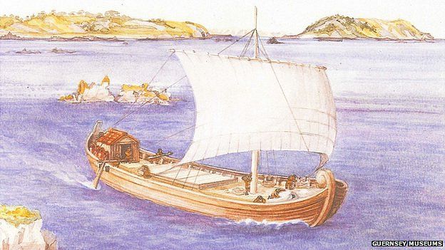
A Roman merchant ship for ocean trade
Less frequently considered Chinese texts like the "Hou Han-Shou", written between the second century B.C.E. and the second century C.E., and "The Sea Route from Guangzhou to Countries in the Indian Ocean", a late Tang Dynasty document written in the eighth century, which underscore the island’s connection to the East, are equally relevant to a discussion of regional commerce.

Additionally, we must pinpoint the recent discovery of Roman coins in southern Japan (Okinawa), that demonstrates the existence of commerce between Rome and the far east through India and Ceylon.

SOURCES FOR INDIAN OCEAN TRADE

Evidence for Indian Ocean trade is well-represented in Greek and Roman literature especially in the above-mentioned text, the "Periplus Maris Erythraei", which is considered the “most detailed and comprehensive surviving account of Roman involvement in the Eastern commerce.”Written by an un-named, Romano-greek merchant between the first and third centuries C.E., the text was likely intended as a guide for other merchants and subsequently contains a considerable amount of first hand knowledge of the trade, including information on the routes and various ports in Arabia, Africa, and India. It contains distances between locations, principal anchorage points, and lists of merchandise, making it an invaluable resource for any ancient merchant determined to undertake a commercial expedition to the Indian Ocean.

Where ancient Sri Lanka is concerned, the Periplus is not well detailed. The author indicates in the text where the island was, i.e. beyond India, and calls it Palaisimundu or Taprobanê; he also writes that its northern parts were civilized and states that the island produced pearls, transparent gems, cotton garments, and tortoise shell. He additionally exaggerates the size of the island and writes that it projected west into the ocean, orienting it east-west as opposed to north-south. He is not the only ancient author to do so. Onesicritus of Astypalaea (c. 360-290 B.C.E.) a Greek commander in Alexander’s fleet whose writings were preserved by Strabo (c. 64/63 B.C.E.-24 C.E.) and by Pliny (c. 23-79 C.E.) commented on the island’s size and its distance from India.67 Strabo quoted Onesicritus as having written that Taprobanê was 5000 stadia in size and 20 days’ voyage from the mainland, though whether this journey was from the Indus delta or from the southern end of India is unclear. Pliny quoted Onesicritus as having written that Taprobanê was for a long time considered to be another world. A fragment from the Greek writer Megasthenes (c. 350-290 B.C.E.), preserved by Pliny, described Taprobanê as richer in gold and pearls than India. Eratosthenes of Cyrene (c. 275 194 B.C.E.), an Alexandrian scholar whose writings were also preserved by Strabo, wrote that Taprobanê was seven days’ journey south of India and measured, length-wise, about 8000 stadia in the direction of Ethiopia. Pliny credits Eratosthenes with different measurements: the island supposedly measured 7000 stadia in length and 5000 in breadth and had no cities but 700 villages. Again, the island was thought to run east-west towards Africa and its size was overestimated.

Hipparchus of Bithynia (c. 190-126 B.C.E.), whose writings were preserved in the work of the Roman geographer Pomponius Mela, commented that Taprobanê was either a very big island or the first part of another world. Strabo commented that Taprobanê, which he places in front of India, was no smaller than Britain. The size of both Britain and Taprobanê were exaggerated and both came to be thought of as possessing parallel characteristics. As the “ends of the known world” they provided symmetry, with the northern part of Britain turned eastward to hug the coast of the European mainland and the southern part of Taprobanê extended westwards towards the eastern shore of Africa. Strabo, placing Taprobanê in the real world, pinpoints the island opposite the ‘Cinnamon bearing Land,’ i.e. Somalia. Finally, Ptolemy (c. 90-168 C.E.), though similarly misinformed about Taprobanê’s size, was much more accurate concerning its shape and its north-south orientation.

According to Pliny, the Mediterranean world had known of the island’s existence since the time of Alexander the Great, but direct contact with the island did not begin until the reign of Claudius (41-54 C.E.). Young adds that there appears to have been limited or indirect contact between the Roman Empire and Sri Lanka, especially prior to the fourth century. Indeed, the Periplus implies that the strait between India and Sri Lanka was the furthest point normally reached by western vessels trading with India, due in part to the fact that Mediterranean vessels may have been too large to easily negotiate the shallow straits between India and Sri Lanka.

Such Greek and Roman sources reveal that Sri Lanka was known to the Mediterranean world, partly as a distant island south of India and partly as a far-away ‘other’ – a producer of exotic goods whose inhabitants lived long lives. What sources like the Periplus Maris Erythraei make clear is that voyages across the Indian Ocean were part of established trading routes that involved both Mediterranean and Indian craft, potentially even the vessel recently discovered off Sri Lanka’s southern coast, the Godavaya shipwreck.

Prosperous commercial activity along India’s western coastline between the first century B.C.E. and the second century C.E. is well-attested to by non-western sources particularly in Tamil poetry written in the centuries following the height of commerce between Rome and India. In the Tamil poem Maduraikanch, for example, written between the first and second centuries C.E.,

Large ships on which high flags on mast-tops wave Spread out their sails and cleave the rolling waves, Tossed by the winds of the great dark, treble sea On which rest clouds. They come to the sound of drums To the port, their trade successful, with the gold That much increases people’s wealth.

The Tamil poem Pattinapalai, written before the third century C.E., describes the port city of Kaveripattinam and the travel of goods between the port and the country’s hinterland:

So goods flow in from sea to land, And also flow from land to sea. Unmeasured are the abundant wares Here brought and piled.

Another poem denotes that merchants arrived at ‘flood time.’ Foreigners, or Yavanas, were primarily traders, but Tamil poetry also attests to their presence as craftsmen and bodyguards.86 Yavanas are mentioned drinking and wandering along the streets at night; all of which provide interesting evidence of their presence in the early centuries of the Christian era.

INDIAN OCEAN TRADE: MERCHANTS AND ROUTES

Before the arrival of the Romans, the Ptolemies of Egypt had begun to exploit trade with both India and Arabia through the construction of ports along the Red Sea coast. Although such trade was well established by the end of the Hellenistic period (323 B.C.E.-31 B.C.E), Strabo indicated that the volume of the commerce was nowhere near as large as it was after Rome’s annexation of Egypt (31/27 BC):

When Gallus was prefect of Egypt, having accompanied him and ascended to Syene and the borders of Ethiopia, we found that even 120 ships were sailing from Myos Hormos to India, but under the Ptolemaic kings only a very few dared to sail and to trade in Indian goods.

Sailing routes across the Red Sea and Indian Ocean have received a substantial amount of scholarly attention. The Periplus of the Erythraean Sea indicates that such routes were dictated by the monsoons, with merchants utilizing the southwest monsoon winds for outbound voyages and the northeast monsoons for return voyages. During the summer months the monsoon winds blow violently from the southwest, suspending most sailing activity from May through September along the west coast of India and the south Arabian coast; the northeast monsoon dominates between November and April. Sailors making the journey to India left from Myos Hormos and Berenike in July sailing down the Red Sea to the Arabian port of Mouza or to the port of Okêlis before following the coast along the southern Arabian shore as far as Kanê. From there they either sailed to India’s northwest coast, to the ports of Barbarikon and Barygaza, or to the southern part of the Indian sub continent, and the ports of Muziris and Nelkynda

Long-distance trade with Arabia and India was greatly facilitated by the use of the monsoon winds, which enabled merchants trading with India to travel there directly rather than make a long and dangerous coastal voyage. Prior to this, few ships made the trip directly and cargoes were transshipped from Indian and Arab ships at one of the southern Arabian ports. The Periplus Maris Erythraei, for instance, mentions a time when there were no direct sailings from Egypt to India and all cargo was transshipped at Aden. After the discovery of the monsoon winds by Greek seamen, Mediterranean ships made the crossing directly. Vessels arrived in India in September or perhaps early October, depending on when they had initially departed. Ships left for the return voyage according to the Periplus, at the onset of the northeast monsoon in early November, though vessels could leave as late as December or January.

The Periplus of the Erythraean Sea, however instrumental and crucial to the study of maritime trade in this region, is not the only textual source relevant to this discussion. Chinese sailing directions in the "Hou Han-Shou" (the Historical Book of the Han Dynasty), written between the second century B.C.E. and the second century C.E., clearly attest that the country Yibuchen lay south of India. A late Tang Dynasty document written in the eighth century, The Sea Route from Guangzhou to Countries in the Indian Ocean, is more helpful in that it describes a venture from Canton to a variety of places in the Indian Ocean, including Sri Lanka, providing approximate sailing times in ‘Li’ or days. These documents help clarify the extent of Sri Lanka’s maritime connections.

In India, the ports of Barbaricum (modern Karachi), Barygaza, Muziris, Korkai, Kaveripattinam and Arikamedu on the southern tip of India were the main centres of this trade with Rome.

Furthermore only two visits to Sri Lanka by Romans have been officially recorded: that of a freedman of Annius Plocamus in the first century A.D., which resulted in the sending of a delegation from Sri Lanka to Rome during the reign of the emperor Claudius (A.D. 41-54) (Pliny N.H. VI.23.84), and that of Sopatros, probably in the fifth century A.D. (Cosmas Indicopleustes, Christian Topography XI.17-19).

Indeed Pliny wrote that Annius Plocamus, a Roman who was related to the Emperor Claudius, sent one of his sailors to explore the seas east of Roman Egypt. The latter landed in Hipporos, a port on the southwestern coast of the island of Taprobane. He stayed there for six months, the time to learn the language and customs. He left towards Rome with four ambassadors of the island. There he said that "...the island had 500 cities. Palesimundium was the capital, a city of 200,000 inhabitants in the center of the south coast, bordered by the river of the same name, one of the two largest rivers of the island; the island was also home to Lake Mégysba, a large inland lake full of islands (home to pasture); a second great river, the Cybara, watered the North Island towards India. The island was 2000 stadia (~ 400 km) long, which corresponds to the dimensions of Ceylon. The island was rich with precious stones, marble, gold, silver, pearls ... The king was dressed like the Greeks, while his people dressed as Arabs...."


All this confirms the existence of huge trade between Rome and Taprobane since Augustus times.

Furthermore Chandra Tilake Edirisuriya wrote in detail that: "Pliny relates that in the time of Claudius Caesar (41-54 CE), a freedman of Annius Plocamus, while coasting off Arabia, was carried by the winds, and after drifting for 15 days, made land at the haven of Hippuros in Taprobane, where he went ashore and was hospitably entertained by the king at the capital Paleisimundus, for six months.The freedman then returned to Rome taking with him two "Sinhala ambassadors" led by one Rachias (ratiya or ratika; a district chieftain), who were sent by the Sinhala king to establish direct commercial contacts with the Roman emperor. An inscription of Annius Plocamus recently discovered in Egypt, is dated 5 July 6 CE, in the reign of Augustus and proves Pliny to have been wrong in ascribing the story he relates to the time of Claudius. Further evidence that the Roman emperor was actually Augustus is provided by the commentary to the Mahavansa which states that King Bhathikabhaya of Sri Lanka (22 BCE-7 CE), the contemporary of Augustus, sent ambassadors to "Romanukkharattha" (or the country of the Romans) and obtained coral, a well-known product of the Mediterranean, with which he had a net ornament made for the Ruvanveliseya at Anuradhapura. Pliny purports to describe Taprobane and its inhabitants according to the accounts given by the Sinhala ambassadors, but it is evident that much of what they are supposed to have said has been misunderstood. The Periplus asserts that the name Taprobane had been replaced by 'Paleisimundu'.Direct trading between the West and Sri Lanka began towards the end of the 1st century CE and developed rapidly thereafter. The far-famed but little-known island of Taprobane became a reality to Western merchants. Numerous first-hand accounts of the island and its people and products became available through mariners to Greek and Roman geographers, and this material formed the basis of the altogether exceptional description of the island computed by Ptolemy about the middle of the 2nd century CE. Ptolemy calls Sri Lanka 'the island of Taprobane which was formerly called Simondou and now Salike' and he adds that "the inhabitants are commonly called Salai." 'Salike' and 'Salai' are from Sinhala. Ptolemy fell into the same error as other geographers in exaggerating the size of Sri Lanka to 14 times its actual area, but gives its general shape and outline with greater accuracy than the Portuguese did in the 16th century. The wealth of information which he gives shows that by the 2nd century Western traders and mariners had acquired a remarkably good knowledge of the coastal and interior topography of Sri Lanka.The Axumites had begun to monopolize the Indian sea-borne trade, by the 4th century and the Romans used them as middle-men. Roman commerce with the East was revived by Emperor Constantine and in the year 362 CE an embassy from Serendivi or Sri Lanka was received by Emperor Julian. The Arabian form, Serendib, of the name of Sri Lanka, had already gained currency in the West. Sri Lanka had become the entrepot of sea trade between the Near East, India and the Far East, by the 6th century. Persian and Axumite ships from the West, Chinese and South-East Asian ships from the East and the shipping of India met in the harbours of Sri Lanka, principally Mahatittha, now Mannar, and exchanged their merchandize as well as purchased the products of Sri Lanka. Great wealth accrued to the Sinhala kings. The trade contacts with the Western world, thus inaugurated, continued during the subsequent centuries up to the fall of the Roman Empire in 476 CE, as indicated by the discovery of large hoards of Roman coins at various places in the island."

With the commerce came to Taprobane even a huge amount of Roman coins, that was used by the Roman merchants to pay for the local merchandise and that also was imitated by the Taprobane authorities, who created similar bronze coins

Bronze imitation of a Roman coin in Taprobane during the Antonine period


Roman coins and contemporary local imitations of Roman coins were in wide circulation in Ceylon/Taprobane for a period of at least four centuries, starting in the third century CE and until the seventh century (during byzantine times).

Taprobane was situated on the maritime trade routes between Rome and China and traded many commodities such as jewels, pearls, camphorwood, spices and ebony with the Romans over this long period. The Roman historian Pliny the Elder recorded that four ambassadors of Taprobane were sent to Rome during the reign of King Chandhrakuma Siva (44-52 AD) and it is probable that some trade commenced at that time.

Large hoards of copper or bronze Roman coins and contemporary Indo-roman imitations have been found at many places in Lanka with a large hoard being found in 1987 at Sigiriya. The coins are always very worn indicating a wide and constant circulation and the roman coins are usually third century and later in age. These hoards suggest that the roman and indo-roman coinage was probably used as small change long after the minting date of the coins themselves. Occasional gold trade coins from Rome are also found in Taprobane, like a Byzantine Roman solidus of Heraclius and Heraclius Constantine (610-641 AD).

INDIAN OCEAN TRADE: THE COMMODITIES

Roman traders typically used coin to acquire such exotic eastern goods though gemstones, fabrics, corals, and mineral powders such as antimony, sulfide, and yellow orpiment were also traded. Large quantities of raw materials including glass, copper, tin, and lead were also in demand in Sri Lanka. Additionally, iron is mentioned in Pliny’s Natural History as well as in the Periplus of the Erythraean Sea where ‘Indian iron and steel’ are specifically denoted.

The Periplus specifies that in Barbarikon, a port on India’s northwest coast, traders could purchase costus (used as a medicine), bdellium, lykion, nard (a medicinal unguent occasionally used in cooking), turquoise, lapis lazuli, silk, cloth, yarn, and indigo clothing. These items could be purchased by Western merchants or exchanged for printed fabric, multicolored textiles, peridot, coral, storax (a resin used in medicines), perfumes, frankincense, glassware, silverware, and wine. Roman money – written in the Periplus as δηνάριον (denarii) – could be exchanged in the port for local currency at a profit. Following India’s coastline south to Barygaza, a port and industrial center, the author of the Periplus indicates that there was a market for foreign wine, metals (including copper, tin, and lead), coral, peridot, cloth, storax, yellow sweet clover, raw glass, realgar, sulfide of antimony (used primarily for the eyes, both as a cure for sores and as a cosmetic applied to the lids and lashes), and gold and silver currency. Barygaza exported nard, costus, bdellium, ivory, onyx, agate, lykion, cloth, silk, yarn, long pepper, among other items brought from nearby ports. Further south, Muziris and Nelkynda were markets for peridot, multicolored textiles, sulfide of antimony, coral, raw glass, copper, tin, lead, wine, realgar, orpiment, grain, and a ‘great amount of money’.

Lionel Casson comments that ‘money,’ or Roman coinage, was emphasized in the Periplus in reference to these two ports to underscore the necessity of having silver and gold currency to purchase goods at Muziris and Nelkynda; elsewhere bartering seems just as prominent a strategy. Muziris and Nelkynda exported pepper, fine-quality pearls, ivory, Chinese silk, Gangetic nard, malabathron – a kind of cinnamon from trees in northeastern India – as well as a variety of transparent gems, diamonds, sapphires, and tortoise shell. While the author rarely comments on the volume of the trade with India, he does write at one point that the vessels departing Muziris and Nelkynda carry full loads due to the quantity of pepper and malabathron they pick up at these two ports. Pliny, whose figures owe more to Stoic moralizing on the cost of luxury than to imperial customs receipts, attests that 50 million "roman sestertii" per year were sent to India to pay for goods; elsewhere in his Natural History he claims that 100 million sestertii were spent yearly upon all the goods imported from India, China, and Arabia. Pliny also quotes prices of 4-15 denarii per pound for various types of pepper, 40-75 denarii per pound for nard leaves, and 300 denarii per pound for cinnamon.

Literary complaints about eastern luxuries and corrupt ‘luxurious’ living developed alongside a steady market for such eastern goods. Propertius (c. 45-15 BC) for instance, who condemns Indian gold, Red sea pearls, Tyrian purple, and Arabian cinnamon and criticizes imported beauty aids – perfume, make-up, jewelry, hair-dye, and diaphanous garments – draws on an established ‘anti cosmetic’ tradition in his poetry. Ovid (c. 43 BC-17 AD), similarly mentions silks, decorated cotton, pearls and various gemstones, as well as other decorative materials such as shells, tortoiseshell, coral and ivory, perfumes and unguents, and writes that a ‘middle way’ should be found between neglect and over-refinement. Culinary items, including pepper, cinnamon, and cassia, for example, are also mentioned. Such goods would have been coming to Rome from the Far East, from Arabia and India, at a time contemporaneous with the Godavaya shipwreck.

Gary Young, who has studied the various routes and communities involved in Roman commerce with the East, cautions against indiscriminately denoting such products as ‘luxury goods,’ or assigning the demand for such items wholly to a Roman taste for luxuria. While some goods were indeed luxury goods, many commodities had medicinal or religious applications. Frankincense and myrrh, for example, were predominantly items of religious significance, burned in honor of the gods at temples and at funerals for centuries. Literary evidence for the use of eastern trade goods in the manufacture of medicines includes Dioscorides’ (c. 40-90 AD) De Materia Medica, which dates from approximately 65 AD and is one of the most comprehensive ancient treatises concerning the medicinal uses of many eastern trade items. Eastern goods were especially prized for their perceived properties as antidotes, which made them useful for cleansing wounds, defeating infections, and as preventives against poisoning. In his writings, Theophrastus (c. 372-288 BC), for one, noted the power of pepper as an antidote.

Any discussion of Indian Ocean trade would be incomplete without the wealth of information that has been gained from archaeological excavation work; together with literary references such resources help contextualize the material carried onboard the Godavaya shipwreck. A commercial relationship between India and the western world is confirmed by abundant archaeological evidence, including excavation work carried out successively in 1945 by Mortimer Wheeler, in 1947-48 by Wheeler and J.M. Casal, and in 1989-1992 by Vimala Begley at the port of Arikamedu.

Arikamedu, one of the emporia of Roman trade on India’s Coromandel Coast, has come to be regarded as essential for the study of overseas commerce with the Mediterranean world during the so-called “Indo-Roman” trade period – a term that has prompted some controversy. Indisputable evidence for commerce with the Mediterranean exists in fragments of transport amphorae, cups and plates of terra sigillata, ceramic lamps and unguentaria, blue glazed faience and glass bowls found at the site. Two-thirds of the amphora fragments found at Arikamedu during the 1941-1950 excavations come from wine jars, suggesting that wine was a principal commodity sent to India from the Mediterranean. Many of the fragments originated in Roman Greece, from the island of Kos, though fragments of Knidian and Rhodian amphorae have been found as well. Fragments of Koan amphorae, originating in Campania, have led to the suggestion that wine from Greece was later supplanted at Arikamedu by an Italian production. In addition to wine jars, fragments of Spanish jars for garum sauce and olive oil have been found as well. Sherds of terra sigillata, a slipped Roman ware, found in the 1989-92 excavations at Arikamedu and dated to the first quarter of the first century C.E., are thought to represent personal possessions, novelty items, or gifts. While typically considered part of the assemblage indicating resident foreigners, a sherd found with “megalithic” writing has caused speculation that some terra sigillata pieces were sold, bartered, or gifted to the local population.

Pattanam, a site on India’s southwest coast recently identified as ancient Muziris, has also provided evidence for Indo-Roman trade; Mediterranean contact is represented by readily identifiable ceramic material, including a Dressel 2-4 amphora, as well as other finds of imported Roman amphorae and related fine wares. Such artifacts date from between the late first century B.C.E. to the fourth century C.E. Remnants of Roman glass bowls, fragments of painted glass objects, and glass pendants discovered at the site are also suggestive of personal belongings rather than merchandise.

Evidence further supporting the supposition that Muziris may have had a Roman ‘merchant colony’ comes from the Tabula Peutingeriana, a medieval map depicting the Roman world as it was in the first century C.E. This map shows a building marked as "Templum Augusti" (Temple of Augustus) at Muziris. Young argues that such a structure would have been built only by subjects of the Roman Empire, likely ones who either lived in Muziris or who spent a significant portion of their time there. Young further argues that the presence of foreign merchants is supported by the Periplus, in a passage that mentions “enough grain for those concerned with shipping, because the merchants do not use it.” These merchants who do not use grain are thought to be Indians who would instead have eaten rice, whereas ‘those concerned with shipping,’ are thought to have been resident foreigners.

Roman Map showing "Templum Augusti" in Muziris, southern India. Taprobane can be seen at the bottom of this map, called "Tabula Peutingeriana"
Roman commodities also passed through Vasavasamudram, an ancient port north of Arikamedu, and Alagankulam, a port city south of Arikamedu. In northwest India, long-distance maritime connections during the last decades of the first century B.C.E. and the early years of the first century C.E. are supported by findings of Mediterranean amphora fragments found off Bet Dwarka Island. Nevasa, in western India and excavated between 1954 and 1956, and again between 1959 and 1961, offers additional evidence for commercial interaction between the Mediterranean and India. Fragments of Italian Dressel 2-4 amphorae – a distinctive ware used primarily to transport wine – dated to between 25 BC and 100 AD, and a sherd thought to belong to a late Rhodian amphora, constitute some of the best evidence the site has to offer for Mediterranean contact.

In Sri Lanka, at sites such as Anuradhapura, Tissamaharama – where Roman amphorae and Islamic glazed wares have been discovered – and Mantai, there is evidence supporting Sri Lanka’s involvement in early trade networks, primarily with India. Sri Lanka’s close relationship with its northern neighbor, India, is particularly important to understanding the region’s commercial networks. The Buddhist chronicles, the Dipavamsa and Mahavansa, written in the fourth and sixth centuries, attest to the arrival of Prince Vijaya and his Sinhalese followers from northern India in the sixth century BC. Archaeologically there is much evidence to tie the two countries together. Mantai, for example, situated at the northwest tip of Sri Lanka and occupied from the fifth century B.C.E. to the 11th century C.E., represents a major point of contact between South India and Sri Lanka with excavation work supporting extensive trade. Such contact is relevant to the proposed thesis work here as the glass found onboard the Godavaya shipwreck is thought to have originated in South India. In fact, many of the artifacts found onboard the Godavaya shipwreck – ceramics, stone querns, glass ingots, and iron ingots – suggest a close association with southern India.

Indo-Roman commerce is also well-represented at such sites as Berenike, on Egypt’s Red Sea coast, where fieldwork has shown that the port functioned “as a conduit for merchandise, people, and ideas passing between Egypt and the Mediterranean basin on the one hand and the Red Sea and Indian Ocean littorals on the other.” Textile finds at Berenike include pieces of a sail and rope fragments, which originated from India; such material supports ‘direct’ trade and may mean that vessels like the Godavaya ship or others like it could have sailed across the Indian Ocean to Africa or Egypt.

Archaeological finds at Arikamedu and other sites verify that imported western goods were brought to India’s eastern coast as well as to its more accessible western one. These commodities may not have been transported in Roman vessels, however. Casson argues that Indian vessels rather than Mediterranean ones handled India’s east coast trade, utilizing small craft, which hugged the coastline, to shuttle back and forth between the subcontinent’s east and west ports. Shipments of goods arriving from the Mediterranean were received once a year, in ports on India’s west coast, in September or early October. These goods were then forwarded, likely by Indian merchants, to India’s east coast ports. While taking part in the trade required a formidable amount of capital in the west, there were opportunities for small-scale operators on India’s east coast.

Participation in such commerce was hugely profitable to justify the risk and expense involved. The Muziris Papyrus, discovered in 1985, which constitutes part of an agreement drawn up in Muziris between a second century C.E. creditor and a merchant, underscores the enormity of the investment represented. The document concerns a shipment of goods, including nard, ivory, and textiles – items frequently found among India’s exports – and a calculation of their value. Originally thought to be the remains of a maritime loan, the document may instead represent a separate contract between the two parties concerning the security of the goods involved, drawn up once the commodities had arrived from India. Given the effort and time involved in shipping goods from India to Egypt in the second century C.E., it has been suggested that the papyrus represents a supplementary agreement meant to detail precisely the responsibilities of the borrower from the moment the shipment arrived safely at its Red Sea port. The papyrus additionally underscores the monetary investment involved in Mediterranean trade with India.

TRADE BEYOND THE INDIAN OCEAN

Evidence for Indian merchants trading in ‘western’ ports exists in the form of little-publicized epigraphical fragments from the Red Sea port of Quseir al Qadim (Myos Hormos). Graffiti inscriptions with Tamil names in Tamil-Brahmi script as well as an ostracon with a Prakrit inscription recording the goods or personal possessions of individuals traveling or residing in Egypt indicate the presence of Tamil speakers on Egypt’s Red Sea coast. These have been dated to the second or third century C.E. Such documents, though fragmentary, help corroborate and personalize the corpus of Greco-Roman sources concerning the flourishing trade between India and the Roman Empire. Non Roman pottery sherds found at Khor Rori in Oman and at Berenike in Roman Egypt may also be indicative of active participation by Indian or other easterners in the Mediterranean; such evidence contests arguments against the direct participation of South Indian merchants in overseas commerce.

Some ancient merchants may have traveled as far as China in search of profitable commerce. Given that the voyage to India was relatively commonplace in the first century C.E., it seems more than plausible that a few sailed further east.

This is supported by chinese court recods that detail visit by Roman traders to Southeast Asia and China. The most famous of these accounts is found in the Hou Han-Shou, or Annals of the Later Han Dynasty, a far eastern source compiled in the fifth century C.E. by Fan Yeh of the Sung Dynasty (420-477 C.E.). These annals, which cover the period between 23 C.E. and 220 C.E., record that in 166 C.E. an embassy from king An-tun from Ta-chʻin (alternately Ta-ts’in) arrived from Annam (Vietnam) and sent gifts of ivory, rhinoceros horn, and tortoiseshell to the Han court. Ta-chʻin, or Ta-ts’in, has been identified by Friedrich Hirth as the Chinese name for the Roman East and An-tun as the Chinese rendering of Antonius. Ferguson additionally comments that the term Ta-ts’in was generally applied to mean those from the Mediterranean and underscores this as applicable to the Seleucid kingdom, to Nabataean traders, to the Egyptian empire of Alexandria, and to Rome and its domain.

T-chuan, i.e. “traditions regarding Western Countries,” part of the Hou Han-Shou, contains a description of the westernmost countries described in Chinese literature prior to the Ming dynasty. Mentions of storax, glass, and precious stone architectural ornaments, foreign ambassadors, and dangerous road conditions with tigers and lions causing travelers to resort to caravans, suggested to Hirth that Ta-ts’in was not Rome itself, but one of its eastern provinces. Hirth further presumed from such records that goods went by Chinese junks from Annam to Taprobanê, or the coast of Malabar, whence they were shipped to the Red Sea. This account may provide evidence of Roman merchant activity in the area of Southeast Asia, and such activity is additionally attested in later Chinese records. The Liang shu, which chronicles some of the events of the period following the collapse of the Han Dynasty in 220 C.E., records that in 226 C.E. Chi’in Lun, a merchant from Ta-chʻin, arrived in Chiao-chih (the Han province of northern Vietnam) and was sent on to the court of the Wu Emperor at Nanjing. Although the work’s compilation in the later seventh century C.E. renders its accuracy about events some 400 years earlier somewhat questionable, it is still worth mentioning here. These same annals indicate that merchants from Ta chʻin were active in parts of Cambodia and Vietnam. Discoveries of Roman gold medallions at the trading port of Oc-eo, near Ho Chi Minh City in Vietnam, give greater credibility to Chinese and Roman sources that speak of Roman trading activity in Southeast Asia, especially in the second century C.E. Recent finds of Mediterranean artifacts in Thailand, Vietnam, Malaysia, and Indonesia further support contact between these areas and the western world. Young writes that in the Antonine period and later, some Roman traders may have begun to journey further than India and Sri Lanka and launched trading activity in the region of Indo-China and perhaps as far as China, although such contacts were “presumably rare.”